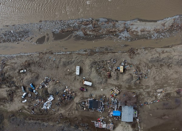
A property damaged by November's floods is seen from the air on the Shackan Indian Band on March 23. The Nicola River was heavily damaged, including large stretches of Highway 8.Darryl Dyck/The Canadian Press/The Canadian Press
November’s storms left British Columbia’s Tulameen River full of junk: mobile homes, travel trailers, pieces of concrete culverts and a destroyed train bridge, a yellow bus, a blue truck, a white SUV and something that might be an ATV. Elsewhere, on the Coldwater, the Nicola, the Similkameen, the Coquihalla, the Thompson and the Fraser rivers, the province has identified 270 clusters of storm debris.
The race is on to clean up all of this – shipping containers, telephone poles, household appliances, roof trusses, tires – in the coming weeks, before this winter’s higher-than-average accumulated snowpack begins to thaw.
Even in a normal year, the spring freshet can bring destructive flooding if it arrives with heavy rains and warm temperatures.
But this is not an ordinary year – and detritus that could create further hazards is just one challenge officials are facing.

B.C. flood debris
Yukon
NWT
Human-made
Kamloops
Lillooet
Natural
Alta.
B.C.
Spences Bridge
Nicola R.
DETAIL
Lytton
Nicoamen R.
Merritt
Hwy 5
BRITISH
COLUMBIA
Kelowna
Hwy 1
Tulameen
Princeton
Hope
Matsqui Dike
Vancouver
Agassiz
Hwy 7
Hwy 3
Abbotsford
0
25
UNITED STATES
KM
THE GLOBE AND MAIL, SOURCE: TILEZEN; OPENSTREETMAp;
drivebc; government of b.c.

B.C. flood debris
Yukon
NWT
Human-made
Kamloops
Lillooet
Natural
Alta.
B.C.
Spences Bridge
Nicola R.
DETAIL
Lytton
Nicoamen R.
Merritt
Hwy 5
BRITISH
COLUMBIA
Kelowna
Hwy 1
Tulameen
Princeton
Hope
Matsqui Dike
Agassiz
Hwy 7
Vancouver
Hwy 3
Abbotsford
0
25
UNITED STATES
KM
THE GLOBE AND MAIL, SOURCE: TILEZEN; OPENSTREETMAp; drivebc; government of b.c.
The fall floods dramatically reshaped the province’s river systems, creating uncertainty about how the runoff will flow. Years of record-breaking wildfires scarred much of the surrounding landscape, adding to the risk of unusual runoff and landslides. A network of dikes needs repairs, and flood-monitoring systems remain damaged.
To put it plainly, B.C. is not ready.
The provincial government tacitly acknowledged the failure to protect communities from floods in this year’s budget, promising to spend tens of millions of dollars to improve forecasting and help local communities better prepare for the growing threats created by climate change.
Bill Blair, the federal Minister of Emergency Preparedness, has also accepted Ottawa’s role in this, but warned that recovery will take time. Municipalities, the provincial government, the federal government and First Nations must work closely to “make sure we do the right things. That’s going to require engineering and environmental assessments,” he said in an interview.
“But the longer it takes to get started, the longer that job will take, so we are working to expedite getting started with that work as quickly as possible.”
Completion of that work is far off. The risk of spring flooding is not.
:format(webp)/cloudfront-us-east-1.images.arcpublishing.com/tgam/PZ3ARXF2JBCZBL53D7FHEAVSQM.jpeg)
:format(webp)/cloudfront-us-east-1.images.arcpublishing.com/tgam/PD6G7WK5OBBFVHDZOZQCOGJ5BA.jpeg)
During November’s storms, rivers exploded with such force that they ripped out portions of highways, railways and bridges. Before and after images created using LIDAR (Light Detection and Ranging) technology reveal precisely how the Coquihalla, Coldwater, Nicola and Nicomen rivers have changed. The mapping, done by consulting firm BGC Engineering, shows how the river channels abruptly abandoned their existing paths and formed new ones.
“Some of the rivers have quite dramatically changed,” said Matthias Jakob, an applied geoscientist with BGC Engineering and an adjunct professor of Geography and Earth, Ocean and Atmospheric Sciences at the University of British Columbia. The riverways are now closer to pipelines, bridges, highways and railways. Banks retreated sometimes by tens of metres, sending huge amounts of debris downriver.
The events, Dr. Jakob noted, produced a case study on the cascading effects of extreme weather. Last summer’s record-setting temperatures and drought led to one of the worst wildfire seasons in B.C.’s history. When the province was hit with a string of heavy rain storms, damage was magnified because the scorched land had become hydrophobic – repelling rain instead of absorbing it. Many of the forests that once helped absorb heavy rainfall are gone.
“All communities that are located along these rivers and that are close to the floodplain are at risk,” Dr. Jakob said. “The problem is, in the short time period between the November events and the freshet, all that can be done is cosmetic mitigation. You cannot design and build an all-new dike to the appropriate geotechnical standards in that time.”
In Princeton, which is beside the Tulameen, the town’s chief administrative officer is acutely aware of the river’s transformation. “It is definitely a new game,” Lyle Thomas said. “We conducted a flood plain mapping exercise last year, but with the flooding in November, we’ll be reviewing that document.”
The province’s goal was to remove human-made flood debris from the rivers and banks where it poses a safety risk or risk to critical infrastructure in early spring. Removal of woody debris that poses a safety risk to critical infrastructure would be next, targeting priority areas before the freshet. That work is still under way.
:format(webp)/cloudfront-us-east-1.images.arcpublishing.com/tgam/FHSPQJFBLBAC7NJDPD67Z7P6PM.JPG)
:format(webp)/cloudfront-us-east-1.images.arcpublishing.com/tgam/CF7PKVIFZRD2NC3XLTDD2KRGO4.JPG)
:format(webp)/cloudfront-us-east-1.images.arcpublishing.com/tgam/SXAJOURYZJCVLNIHJBBCTCBFBU.JPG)
This will be Henry Braun’s eighth spring freshet as the mayor of Abbotsford – and each one brings worry.
The need to upgrade the province’s flood protection has been well documented, he said, but a lack of cash and “endless meetings” allowed years to slip by.
Last November, the Nooksack River overflowed in the relentless rains, which in turn caused the city’s Sumas dike to fail.
In spring, however, the flood risk comes from the Fraser.
The bottom of the river is rising as sediment builds, reducing the effective height of the 100-year-old Matsqui dike, which needs to be raised and fortified. Powerful currents are carving out erosion arcs in the river banks alongside it. And the rock barriers that once armoured the structure have collapsed in places.
In most of B.C., such flood protections are the responsibility of the local government and costly repairs just haven’t been done. The Matsqui dike repairs, along with other flood protection measures needed on the Sumas Prairie, would cost up to $2.8-billion, according to proposals put to city council by the engineering department on April 4. The work hasn’t been done because the city doesn’t have the money, Mr. Braun said.
Both the federal and provincial governments have said they will have to step up and help pay for dike maintenance. After Mr. Blair visited flood-damaged communities in March, he vowed to try to extract an advance on promised disaster funding to help speed repairs.
But Mr. Braun knows how slowly these projects can move. Years ago, Abbotsford sought financial support from the province for a “Band-Aid” repair job that involved constructing rock spurs underwater to redirect the flow of the Fraser River. The province handed over $10-million for the project in 2016, but the work hasn’t started yet.
“We still have not got approval to do the construction,” said the mayor, adding that the city has been working with various government agencies to get a green light. “In the meantime, we’ve recosted the project because we think we’re coming to the end of all this, that maybe this summer we can actually build those spurs. But guess what, $10-million doesn’t buy you today what it bought five years ago. Now it’s $17-million.”
Metro Vancouver municipalities downstream of Abbotsford should also worry about the delays, he says. “I refer to the Fraser Matsqui dike as a ticking time bomb. I just don’t know when it’s going go off. It may not happen for 10 years. … But if we don’t do something, that flood will be 10 times what happened in Sumas Prairie, and that water is also going to wipe out our sewer treatment plant, and our sewage is all going to end up going downstream.”


Life goes on by the Similkameen River in February: At top, Danie and Dian Brooks assess the damage inside their flooded home, and at bottom, Bev Greenwell and Charles Webber stamd by the repaired dike.Caillum Smith/The Globe and Mail
The first rainstorm to hit British Columbia in November was a monster: an atmospheric river of moisture 4,000 kilometres long and 500 kilometres wide. But there was little advance warning of the destructive force it would unleash from any of the multiple agencies that monitor weather-related data points in the province.
Environment Canada tracks the weather and issues warnings when required. The B.C. River Forecast Centre is responsible for analyzing snow pack and seasonal water supply and helps predict flows in rivers and streams to gauge flood risk. Emergency Management B.C. monitors the information from both agencies, and its job is to alert First Nations and local governments when trouble is looming.
At 5:12 a.m. on Friday, Nov. 12, Environment Canada issued a Special Weather Statement that a “series of moisture-laden systems associated with an atmospheric river from the Pacific” would hit Saturday night, bringing heavy rain to the coast. At noon on Nov. 13, the River Forecast Centre sent out a “high streamflow” warning for B.C.’s south coast and Vancouver Island, but the modelling was not for flows exceptionally above average.
Neither statement would have sent people running out to buy sandbags in November on the West Coast.
The first actual flood warning was posted online at 5:30 p.m. on Sunday, Nov. 14, for the Tulameen and Coldwater rivers. Officials with the city of Merritt, next to the Coldwater, didn’t pick up on the notice for hours. “There weren’t any calls that went out with that warning. It was posted to a website, and we became aware of that notice closer to 9 p.m.,” said Merritt’s chief administrative officer Sean Smith. According to Emergency Management BC, provincial officials “made initial contact” with Merritt, Princeton and the surrounding regional district between 6:30 p.m. and 8 p.m., with a co-ordinating phone call at 10 p.m.
By then, there was no time to reinforce the dike. At 11:30 p.m. Merritt started evacuations.
The volume of water flowing through the Coldwater river was twice that of anything previously recorded. It was a one-in-1,000-year event. On Nov. 15, all 7,000 residents were evacuated as high flood waters rendered the city’s waste-water treatment plant inoperable.
“There are some real opportunities to refine and improve warning systems,” Mr. Smith said.

A car travels a repaired portion of Highway 8 west of Merritt, B.C., on March 23.Darryl Dyck/The Canadian Press
In spring, some things can be forecast well in advance. For example, by early April the province should have a clear picture of the past winter’s accumulated snowpack, which creates vulnerability when it melts.
But that is only part of the story, says Armel Castellan, a warning preparedness meteorologist for Environment and Climate Change Canada.
“The snowpack is definitely a huge part of the equation. If you’ve got more snow development, the potential for flooding becomes higher as well. But the big caveat is meteorological,” he said. “The weather that transpires in those critical weeks – usually in May or early June – is going to be what really spells out how the freshet transpires.”
And because of alterations to the landscape caused by droughts and wildfires, and changes to the geometry of the rivers, existing flood models are going to be less reliable, he said. “They can’t take into account an unlimited amount of adjustable data.”
Even gathering data will be challenging this year, as some of the hydrometric stations that help monitor stream flow remain offline owing to damage. The River Forecast Centre is developing other inputs to address the resulting gaps in the monitoring network.
The provincial government is looking at whether it needs additional staffing resources before the spring freshet, and where it could pull those people from, said David Muter, B.C.’s assistant deputy minister for resource stewardship, responsible for the River Forecast Centre and the provincial flood safety team.
“We’ve planned for that flexibility even going back a year, knowing that this year’s freshet season could be a big one,” he said in an interview. An additional worry for the province’s forecasters is that this is one of those La Nina years that tends to bring above-average precipitation in the winter and spring to British Columbia.
“We have been doing some assessments of streams from the November events. The course of a river stream in some cases has changed entirely and that can throw off our modelling. So we may be looking at an entirely new modelling scenario that we’re trying to get our heads around.”
:format(webp)/cloudfront-us-east-1.images.arcpublishing.com/tgam/BUFO5LFEAFFNRDWLHHNOCVGCBU.gif) Lost highway: How floods changed the B.C. Interior forever
Lost highway: How floods changed the B.C. Interior forever
Last year’s atmospheric river dealt enormous damage to Highway 8, also called the Nicola Highway, and changed the course of the river alongside it. The Globe and Mail took a look at how residents are trying to rebuild
We have a weekly Western Canada newsletter written by our B.C. and Alberta bureau chiefs, providing a comprehensive package of the news you need to know about the region and its place in the issues facing Canada. Sign up today.
 Justine Hunter