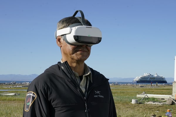
Richard Gordon tests out the virtual reality environment on Qikiqtaruk, Y.T., in an undated handout photo.The Canadian Press
Surrounded by chirping birds, buzzing mosquitoes and waves gently lapping on the shore, viewers travel through time, witnessing a permafrost thaw slump, rising floodwaters and shrubs take over Qikiqtaruk or Herschel Island.
The virtual reality project Qikiqtaruk: Arctic at Risk is transporting people to Yukon’s northernmost point without them ever having to leave home. Using real visuals and sounds, including the cracking and popping of permafrost thaw, the National Geography Society-funded project provides an immersive experience into the effects of climate change on the island in the Canadian Arctic.
“There’s a lot of changes that I’ve seen over my 20 years working on Herschel,” said Richard Gordon, senior park ranger for Qikiqtaruk Territorial Park with Yukon Parks.
Gordon said the coast is rapidly eroding, ice is going out earlier and it’s getting more difficult for elders to read the weather when travelling. He said black guillemots, with the island home to the largest colony of the seabirds in the western Arctic, are also declining as there are fewer of the fish they feed on.
Gordon said the VR project aims to help youth, tourists and others understand what is happening on Qikiqtaruk first-hand, and the importance of working with researchers on management decisions.
“It really gives you a good reality as to what is happening with climate change as it’s happening,” he said.
“If you could see it happening on a small island within your homeland, it’s happening all along that North Slope coast.”
Qikiqtaruk, which is approximately 116 square kilometres and located five kilometres off the north coast of Yukon in the Beaufort Sea, is an important cultural heritage site with Inuvialuit using the island for thousands of years. It’s home to a variety of animals and plants including Porcupine caribou, Arctic terns and Arctic lupine.
In the late 1800s, the island became the main base for commercial whalers in the region and a Euro-American settlement was established at Pauline Cove. The RCMP also established one of their first detachments in the Arctic on the island in 1903, hiring their first special constable there in 1909.
Gordon, who is Inuvialuit, said when he was a kid, his family lived off muskox, caribou, Arctic char and herring from the island and Indigenous people continue to harvest in the area today. Qikiqtaruk was established as a natural environment park in 1987 under the Inuvialuit Final Agreement allowing for traditional Indigenous use to continue.
Isla Myers-Smith, a scientist at the University of Edinburgh and University of British Columbia, has been researching tundra and plants on Qikiqtaruk since 2008. She said since the 1980s there has been an increase in shrubs and grasses on the island along with rates of permafrost thaw and erosion.
Myers-Smith said the idea to develop the VR project came around during the pandemic when researchers were unable to travel to the island.
“I think for a lot of people around the planet, they hear about climate change but they don’t necessarily understand what that means and what it might mean in an Arctic context,” she said.
“For those of us who spend time on the island, it’s amazing how you can make it true to life,” she said of the VR project. “When I have the headset on … I feel like I am in those places.”
Jeff Kerby, a researcher and science photographer at Aarhus University in Denmark, said “seeing is believing” when it comes to changes on the island, the most obvious of which he said is the formation of huge permafrost thaw slumps. He said the VR project brought together Gordon, researchers and immersive content creators.
He said the project helps address accessibility challenges as travelling to Qikiqtaruk requires chartering a plane, which is expensive, or taking a long boat ride. It also helps bridge an empathy gap, he said, connecting people from far away to the island in the Canadian Arctic.
“If we can use this to at least start some conversations or to tie people more into the connection that they have to the island, that’s a great thing, in a way that perhaps pictures can’t,” he said.
Last month, the project won “best in category: visualize” at the XR Prize Challenge: Fight Climate Change at the Augmented World Expo in Santa Clara, Calif. The competition featured projects from around the globe that used augmented and virtual reality to help fight climate change.
Myers-Smith said the project has been shared with community members in Aklavik, N.W.T., to gain feedback and plan to release it later this year or next spring.
This story was produced with the financial assistance of the Meta and Canadian Press News Fellowship.